


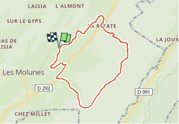
Les Platières - Croaby - sur le Lignon - La Refate

Mariolebeno
Gebruiker

Lengte
8,1 km

Max. hoogte
1314 m

Positief hoogteverschil
228 m
Km-Effort
11,2 km

Min. hoogte
1188 m

Negatief hoogteverschil
228 m
Boucle
Ja
Datum van aanmaak :
2024-02-24 09:59:39.277
Laatste wijziging :
2024-02-26 07:45:22.056
2h10
Moeilijkheid : Medium

Gratisgps-wandelapplicatie
 SityTrail
IGN / Geografische instituten
SityTrail Plus
De wereld gaat voor u open
Over ons
Tocht Stappen van 8,1 km beschikbaar op Bourgondië-Franche-Comté, Jura, Septmoncel les Molunes. Deze tocht wordt voorgesteld door Mariolebeno.
Plaatsbepaling
Land:
France
Regio :
Bourgondië-Franche-Comté
Departement/Provincie :
Jura
Gemeente :
Septmoncel les Molunes
Locatie:
Les Molunes
Vertrek:(Dec)
Vertrek:(UTM)
726080 ; 5137211 (31T) N.
Opmerkingen